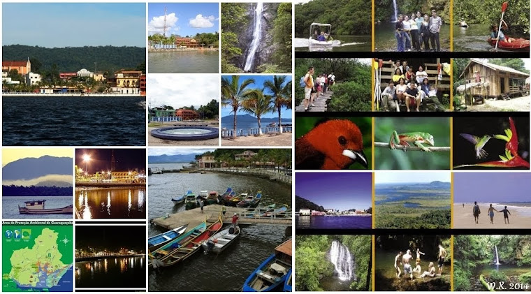
Páginas

terça-feira, 9 de janeiro de 2018

Quem sabe Guaraqueçaba neste fim de semana!!!


Guaraqueçaba: como chegar e o que fazer entre a serra e o mar


Motivos pra conhecer Guaraqueçaba, no litoral do Paraná, existem de sobra. A cidade fica dentro da maior reserva de mata atlântica do país, cercada por ilhas, praias desertas, animais em extinção, cachoeiras e história. De Curitiba até lá são apenas 160 quilômetros e dá pra descer a Serra do Mar pela deliciosa Estrada da Graciosa.

Como ir a Guaraqueçaba por estrada

Se você faz parte do time dos corajosos ou gosta de off road, vai aproveitar o percurso que corta a mata atlântica da serra ao mar. Dê uma olhada no mapa:


VIA ESTRADA DA GRACIOSA

Saindo de Curitiba pela BR 116, sentido São Paulo, você encontra o portal de acesso para a Estrada da Graciosa ( PR 410) a cerca de 40 km da cidade. Depois de descer a serra, um pouco antes de Antonina, entre na PR 340, sentido Cacatu, e siga até o trevo com a PR 405, a estrada de terra que leva a Guaraqueçaba.

VIA BR 277

A partir de Curitiba, siga pela estrada duplicada que leva ao litoral do Paraná até o km 30 e vire no trevo que indica Morretes e Antonina. Antes de chegar a Antonina, entre na PR 340 e depois, seguindo a sinalização, pegue a PR 405.

Como chegar em Guaraqueçaba de barco


Barcos comerciais partem de Paranaguá às 09h00 (todos os dias) e às 13h30 (exceto domingos e feriados). O cais fica na Rua da Praia ( o nome oficial é R. General Carneiro) em frente ao restaurante Danúbio. A passagem custa R$30,00. Retorno às 07h e 14h.
Pra quem está turistando, funciona como um passeio. O barco passa próximo ao porto de Paranaguá mas segue um caminho diferente dos grandes navios. Em meia hora, você está no meio da baía com as montanhas de um lado e as ilhas do outro, incluindo a mais famosinha Ilha do Mel.

O que ver e fazer em Guaraqueçaba

Guaraqueçaba é de uma tranquilidade só. O movimento só aumenta um pouco nos fins de semana de temporada. A praça e as construções históricos formam uma espécie de semicírculo de frente para a baía.
Da época de ouro da cidade, na virada do século 19 para o 20, restam poucos prédios. O antigo mercado municipal, diante do trapiche, abriga um posto de atendimento ao turista. A boa conservação contrasta com o edifício vizinho, um belo casarão que ameaça desabar.


Subindo a rua ao lado, chega-se à Igreja de Bom Jesus dos Perdões, a construção mais antiga da cidade, erguida em 1838 aos pés do Morro Quitumbê. Uma trilha de 600 metros parte dos fundos da igreja e leva ao alto do morro, um belo mirante natural pra quem tem força nas pernas.

Passeios em Guaraqueçaba

Além de apreciar a vista bucólica do centrinho, há também As atrações fora da cidade, nas matas e nas ilhas da grande área de proteção ambiental de Guaraqueçaba.

Os passeios que levam ou pela floresta ou pelo mar não são complicados, mas é melhor reservar um dia para cada um e aproveitar o resto do tempo pra relaxar na pousada. Outra opção é conhecer a linda Ilha de Superagüi. 

                                Reserva Particular  Salto Morato


O acesso para a reserva particular fica a 23 quilômetros da cidade.
Vale a pena o passeio. O lugar é bem organizado, com centro de visitantes, material educativo, banheiros decentes e bebedouros. A entrada custa 10 reais (crianças não pagam). A lanchonete e o trabalho de orientação funcionam de terça a domingo.

Há duas trilhas demarcadas e bem fáceis de percorrer. A Trilha da Figueira leva a uma arvore centenária que projeta as raízes sobre o rio. A trilha principal, com 1500 metros no meio da mata, chega até os pés do Salto Morato, uma cachoeira linda de 100 metros de altura.

Onde ficar

Há muitas  pousadas na região. Indicamos a Pousada do Guará,  do amigo Thon Soá. 


segunda-feira, 16 de dezembro de 2013

WELCOME TO GUARAQUEÇABA!


Município
Guaraqueçaba PR
População
7.870
Área/km
2.020,09
Gentílico
guaraqueçabano
Bioma
 Mata Atlântica
Bandeira

Densidade p/ Km²
3,9
Divisa
Costeira


GUARAQUEÇABA FOI FUNDADA EM 11 DE MARÇO DE 1545.


quarta-feira, 15 de maio de 2013

GUARAQUEÇABA - Get to know the most preserved forest rain area in Brazil...

We would like to introduce you  one of the most important forest rain remaining in Brazil, considered reserve of biosphere by UNESCO - Guaraqueçaba.

We're looking for partnership with foreigners institutions to develop social projects on this area. 

We need your support to sponsor the social developing and helping the native people to live in this region without destroying the environmental. 

We invite  YOU  to get to know this fantastic place in Brazil and maybe we could establish a partnership to develop some project here. 


Guaraqueçaba - Located in the coastal area of Paraná 10 meters above sea level, it has  the largest remnant of the Brazilian Atlantic Forest in Brazil.  It encompasses an area of 1.915,95 Km2 (315.241 hectare) and holds 4 units of conservation with 7.871 inhabitants in 2012.


Originally, there were several Indian nations in this region. Hence, during the Portuguese settlement, Indians were gradually exterminated from our coastal areas, leaving their heritage that still remains among the local population. Caiçaras are a living example of this fusion between Indians and settlers.

This area was settled by the Portuguese in 1545. It was the first settlement in the state of Paraná. Around the year of 1638. Many miners and fortune-hunters came to explore the rivers looking for gold. Soon after the Jesuits came, they established a religious and agricultural settlement in the Superagui region. The first local community was then established. But only during the last century, when a chapel was built in the hill of Quitumbê, other buildings were constructed forming a small village. Later on it was taken over by the municipality of Paranaguá. In 1947 its autonomy was restored and Guaraqueçaba was recognized as an independent municipality.

There are two main economic activities in these communities: fishing that involves the whole community and agriculture, restricted to familiar maintenance. Besides, they still combine collecting, extractive activities and handicrafts.

The association of fish and yucca flour is one of the most general aspects of caiçaras’ diet, divided in these days between the need for money expressed by the intense relation with urban culture and fear of losing their group’s identity as simple fishermen living in preserved areas.


Guaraqueçaba is comprised mainly by the Dense Ombrophilous Forest (68.6% of total area) and secondary forests (9.1%), indicating a forested landscape matrix; anthropogenic and bare soil areas (0.8%) and the Pasture/Grasslands class (4.2%) were less representative. Slopes were less fragmented and more preserved (96.3% of Dense Ombrophilous Forest and secondary forest) than lowlands (71.3%), suggesting that restoration initiatives in the lowlands must be stimulated in this region. We concluded that most of the region sustains well-conserved ecosystems, highlighting the importance of Paraná northern coast for the biodiversity maintenance of the Atlantic Forest.

The landscape analysis of Guaraqueçaba, showed that the region is dominated by forests (83% of the total area), indicating that the matrix may be considered forested and in a good state of conservation. Differences in land use between lowlands and slopes suggest that management initiatives, such as forest restoration, must be encouraged in most fragmented lowland areas.

The Dense Ombrophilous Forest (68.6% of the total area) and secondary forests (9.5%) were the most representative classes in Guaraqueçaba. Several studies have demonstrated high species richness in areas of primary and secondary forests in the region. Old growth forests are important source of seeds and shelter for animals in the coastal Atlantic Forest. On the other hand, although secondary forests are a limited habitat for some species, some studies have demonstrated that a large number of specialist species can be found in plantations and secondary forests in Atlantic Forest landscapes. Mangroves (5.3% of the total area) are well conserved in Guaraqueçaba region. It is possible that these mangroves are one of the most important fragments in Paraná State, highlighting the significance of its preservation.

Pastures and grasslands (4.2%) and disturbed and bare soil areas (1%) are less representative in Guaraqueçaba. Buffalo farms were common in the region in the 1970s and 1980s. After that, the cattle breeding was abandoned and a large part of the region became protected area.Thus, conservation initiatives should take this into consideration for guaranteeing ecosystem resilience.

Slopes and lowlands are very distinctive landscapes in Guaraqueçaba. Slopes not only comprise a larger proportion of the area (67%), but they are also more forested (Dense Ombrophilous Forest and secondary forest) and better preserved than lowlands (96.3 and 71.3% of the compartment area, respectively). The great elevation in the sea mountain range was one important barrier to anthropization in Atlantic Forest, where the largest remaining fragments are found.


This is a little bit of Guaraqueçaba-Paraná-Brazil, we're looking forward your visiting here!


ADN - Nature Defensors Ecological Association 
(Associação Ecológica Defensores da Natureza) 

Phone Numbers:

55-42-9932-6191